Advanced weather monitoring station with Wildeye® technology in dry open landscape.

Weather & Climate Monitoring

Have the knowledge to make the best weather related decisions, throughout the growing season and from one year to the next.

A weather forecast icon with a cloud and rain for outdoor planning or weather updates.

4G IoT

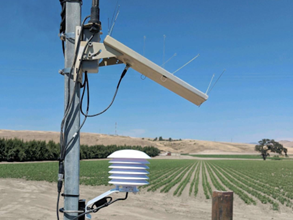
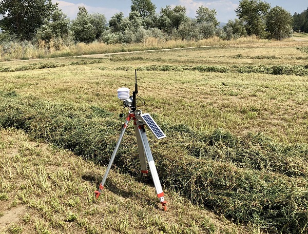
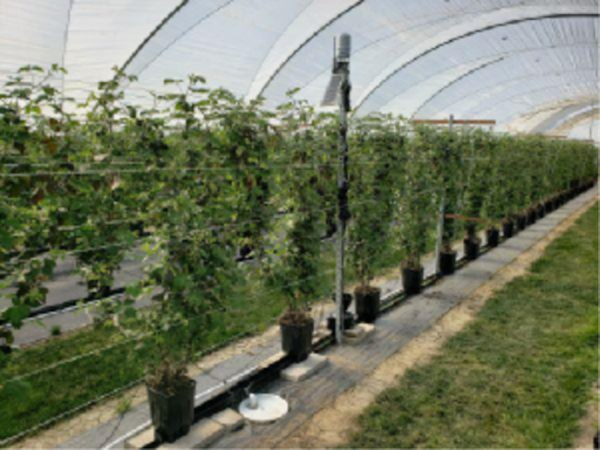
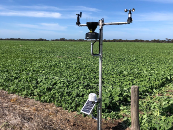
A range of weather & micro-climate monitoring solutions

3am, 4am, 5am. When is the right time to be in the field for frost protection, spraying, cutting, or fertigation?
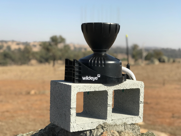
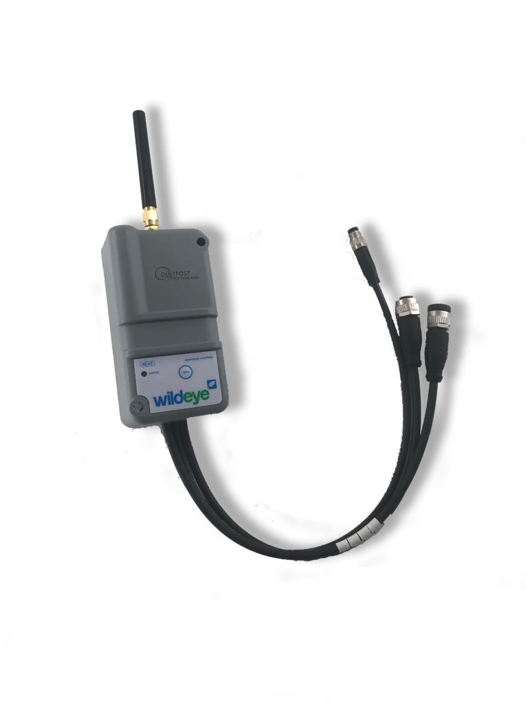
With Wildeye®, connectivity to your field systems and the important information they provide is easy, affordable, accurate and dependable.

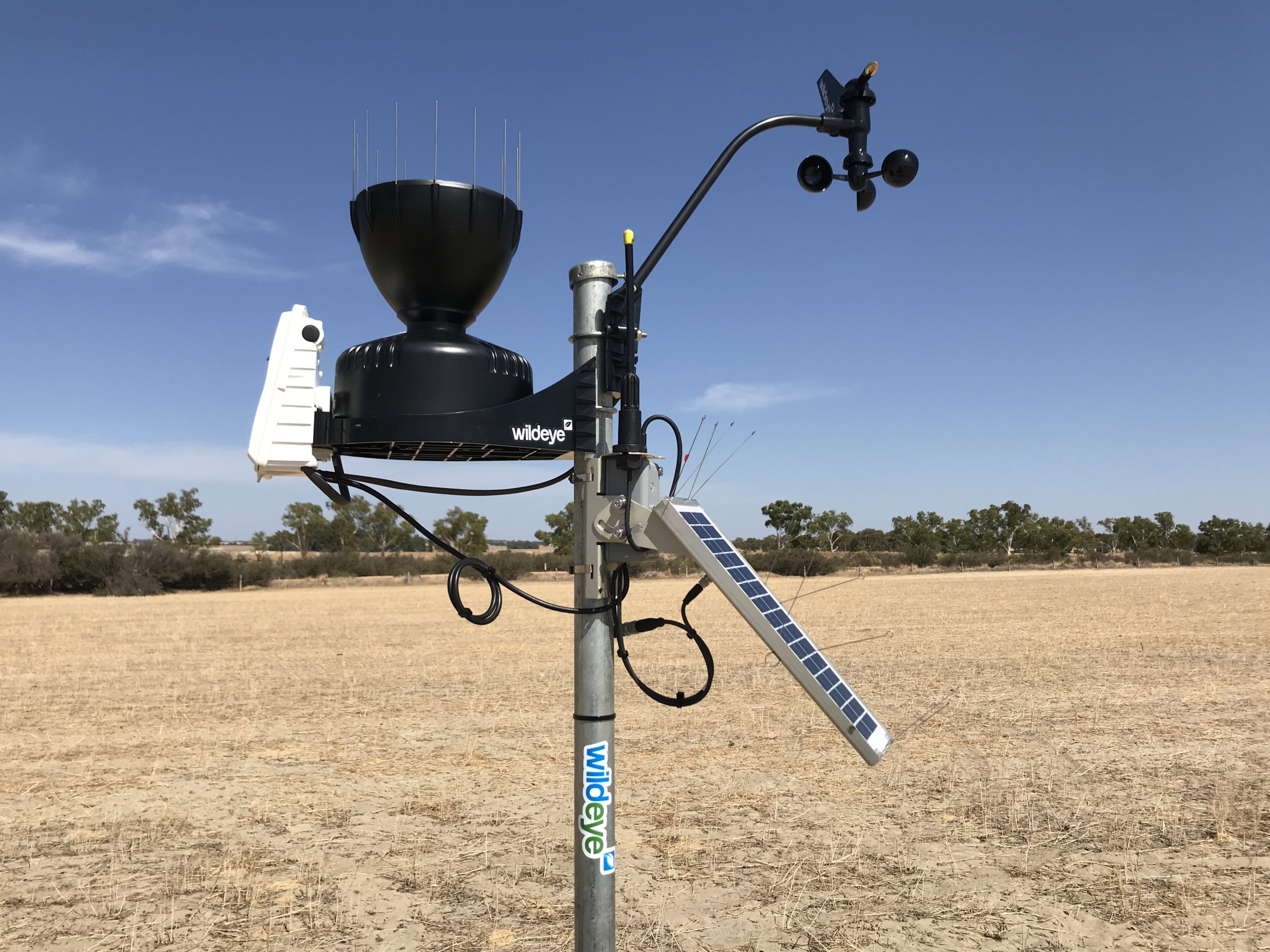
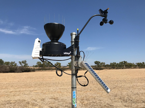
Wildeye® weather stations get you the data you need: temperature, humidity, wind and sun and updates this information directly to your phone, tablet or desktop.

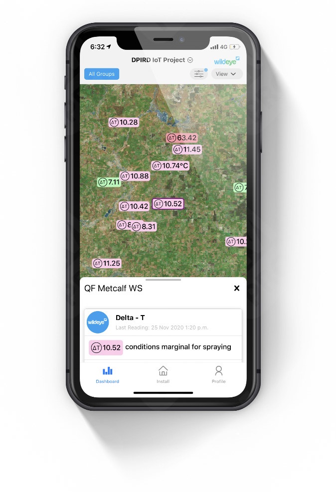
Track your information on Wildeye’s easy-to-read, easy-to customize dashboard.

Select Your Weather Stations Features:

  • Temperature Monitoring with Alerts
  • Evapotranspiration (Et0)
  • Delta-T & Growing Degree Days
  • Chill Portions and Chill Hours
  • Humidity and Leaf Wetness
  • Fire Danger Index
Soil temperature and moisture sensors displayed on a smartphone screen for precision agriculture by Wildeye.

Benefits of Weather & Micro-Climate Monitoring

Automated records

No more notepads, missing pens or blown-away rain records, with secure, automated record keeping in the cloud..

Better and Safer Spraying

Know when the right time to spray is using wind speed and direction, Delta-T, temperature inversion event monitoring.

Phenology and crop health
Monitor degree days, chill portions, frost events etc to understand the progression of crop health and predict yield, quality, frost damage and more.
Understand Microclimate

Weather is spatially vaiable, and your local microclimatic conditions can be significantly different from conditions recorded at offsite weather stations.

Predict adversity

Use integrated agronomic derivations like Botrytis Index, Moldy Mildew index etc to predict the onset of adverse events. Be on the front foot with management decisions and understand fire risk via Fire Danger Indices, generated for your specific location based on your specific conditions.

Validate decisions

Have a wealth of on-site data to justify and review your decisions. Know exactly what the wind was doing when you sprayed last week, what the fire danger index was when harvesting restarted, look up how many degree-days until crop maturity last season etc

Climate monitoring for your unique requirements.

Full weather stations can be expensive and only monitor the local microclimate. Why not monitor more locations with only the sensors you need for your specific application.

Advanced weather monitoring station with Wildeye® technology in open field for agricultural precision.
Full Weather Stations
  • Cost-effective full weather station designed for farms
  • Air temperature monitoring with alerts: frost monitoring
  • Reports growing degree days, delta-T, fire danger, chill hours & portions, mildew index, and evapotranspiration
Solar weather station with outdoor sensors and antennas at agricultural field for precision monitoring, Wildeye® optima solutions.
Temp & Humidity Station
  • Air temperature monitoring with alerts: frost monitoring
  • Reports growing degree days, delta-T, chill hours & portions
  • Place multiple sensors per ranch for micro-climate monitoring
High-precision wildlife monitoring device on cinder block outdoors.
Rain Gauge Station
  • Simple cost-effective rainfall reporting
  • Rain is spatially variable — monitor more fields for less
  • Uses self-emptying tipping bucket gauge
Oscilloscope drone for crop monitoring in fields, capturing precise agricultural data with Wildeye® technology.
Hay-dew Station
  • Designed to report the optimum time to cut hay
  • Includes accurate humidity sensor designed for long-term outdoor operation
  • Includes leaf-wetness sensor
Healthy grapevines growing in a controlled greenhouse environment at Wildeye®.
Compact Weather Station
  • All-in-one sensor with no moving parts has low maintenance requirements and a small form factor
  • Suited to space-constrained environments and remote locations
  • Reports ET as well as all temperature indices
Wind turbine weather station with solar panel in a crop field for environmental monitoring and agricultural data collection.
Retrofit Packages
  • Attach existing weather station sensors to a Wildeye to get superior Wildeye graphs, alerts, and fleet management
  • Will attach to existing sensors by Davis, Climate Minder, John Deere, Vaisala, Meter, Tekbox, and more

We're all ears

Send us a quick email or give our sales team a call to chat with someone who knows their stuff. We've been doing this for 20 years, since before the "Internet of Things" had a name. 

We're all ears

Send us a quick email or give our sales team a call to chat with someone who knows their stuff. We've been doing this for 20 years, since before the "Internet of Things" had a name. 

Reliable Hardware

4G IoT
High-tech Wildeye® wireless drone control system for optimum surveillance.

Designed for harsh environments. Wildeye® connects to global IoT cellular networks for maximum global coverage. There is no need for complicated radio infrastructure on your farm. Scale from one to thousands of sensors with minimal investment.

Wildeye® works out of the box with plug and play connectors to connect infield sensors to the cloud and single button activation to streamline installation and maintenance and reduce costs.

Your Wildeye® can be supplied with either ultra long life internal batteries or a rechargeable version from solar panels, battery packs or mains power.

Compatible with most major suppliers of meters & sensors

Wildeye® can supply a full system, including the right meter or sensor for the job. If you’ve already invested in meters & sensors then you don’t need to start from scratch. You can often upgrade with Wildeye® if your equipment is from a reputable manufacturer. Contact us to discuss if we can retrofit to your existing investment.

High-tech aquatic monitoring device by Wildeye on a boat, showcasing innovative fish detection technology.
Wildeye® advanced wildlife monitoring system for optima surveillance and data collection.
High-tech Wildeye® camera system capturing real-time underwater footage for optimal marine monitoring.
High-precision Wildeye® water quality monitoring device in action.
High-performance WildEye® fishing camera system for underwater surveillance and fish tracking.
High-precision Wildeye® flow measurement device used in industrial applications.
Wildeye® bioacoustics monitoring device on a forest tree branch for wildlife research.
High-tech wildlife monitoring camera for optimal data collection and conservation.
Water quality monitoring device by Wildeye, ideal for wastewater treatment.
High-quality Wildeye® camera equipment for optimal wildlife observation and research.
High-performance Wildeye® optical fiber connectors for reliable data transmission.
High-precision EnviroPro soil probes for accurate soil health analysis and sustainable farming.
Soil moisture management technology by Wildeye® for optimal water balance.
High-resolution image of Campbell Scientific logo showcasing innovation in scientific data acquisition.
Wildeye® water monitoring system logo for environmental and water quality management.

Works where you want it

No need to research radio technologies, install gateways and repeaters or maintain your own computer servers. Every wildeye® device runs on the global IoT standard of CatM1 (or LTE-M) for maximum coverage and communicates directly with the cloud. It’s ready to go. No need to provide a SIM card.

Wildeye® automatically updates device firmware and controls software upgrades so you can concentrate on running your own business.

Blue heatmap overlay on a map of Australia highlighting wildfire or area data for Wildeye® visualization.
Indicative coverage of CatM1 on Telstra Australia. May require high gain antenna. Can also operate on Vodafone/Optus if required. Refer to network operator for detailed coverage maps.
High-resolution US map with digital overlay, showcasing geographic details and state boundaries for enhanced spatial analysis.
Indicative 4G (CatM1 / LTE-M) coverage of Verizon in North America. May require high gain antenna. Can also operate on AT&T & T-mobile if required.
Arrow-up